This page may have Commerce Content. If you buy something from our posts, we may get a small share of the sale. Click here for more.


Editor & Article Writer for Outdoor Wilds
As an Amazon Associate I earn from qualifying purchases. Thank you for helping to support the site.
Major Hiking Trails in the United States
Where should I go for my next hiking trip? This is always a tough question with hundreds of great trails to explore. However, I’ve narrowed down the top options in the country. From coast to coast, here are the major hiking trails in the US.
Please note: The embedded maps will only be available on tablet & desktop browsers.
The Appalachian Trail

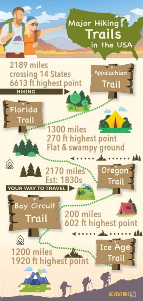
The Appalachian Trail is one of the most well-known hiking trails. It covers over 2200 miles of marked trails extending between Georgia and Maine. If you start on one end and work your way to the other, you’ll pass through 14 states.
It even connects with a trail that continues from Maine into Canada with routes that can take you to Greenland and through Europe.
The trail itself was started in 1921 and completed in 1937. A variety of nonprofits work with the United States Forest Service and the National Park Service to maintain the trail. It is one of three trails considered the Triple Crown of Hiking in the US.
The Pacific Northwest Trail

The Pacific Northwest Trail shouldn’t be confused with the Pacific Crest Trail that runs north and south along the coast. The Pacific Northwest takes you from Glacier National Park in Montana to Washington state and the Pacific Ocean.
It covers over 1200 miles of trail that includes many scenic locations and a variety of landscapes. It was designated a National Scenic Trail in 2009, making it one of the newest entries.
Besides Montana and Washington, the trail takes you through Idaho. It mostly follows the US-Canada border.
Maps and mobile apps for the Pacific Northwest Trail can be found here.
The Florida Trail
If you enjoy the Sunshine State, you may want to try hiking the Florida Trail. It spans 1300 miles as it snakes its way through the state. It was started in the 1960s and designated a National Scenic Trail in 1983.
The Florida Trail is one of the most unique and diverse hiking trails. You get to see an assortment of wildlife and plant life.
The trail starts near the Gulf of Mexico and provides a mixture of beach landscapes, narrow footpaths, and lots of hills. You’ll also reach wet, boggy areas and swampland.
There is Florida Trail app you can find here.
John Muir Trail, California
The John Muir Trail covers a portion of the Pacific Crest Trail and covers 211 miles of land. It stretches from Yosemite Valley to Mt. Whitney.
During your hike, you’ll get to pass through the Sierra Nevada mountain ranges, which are considered to provide some of the best scenic outlooks for hiking.
Before choosing to hike the John Muir Trail, you should be aware that black bears and other wild animals are known to prowl the region. However, with proper precautions, you can still enjoy one of the most scenic hiking trails. For more information on what to do if you encounter a bear read my article here.
Continental Divide Trail
The Continental Divide Trail is one of three trails that comprise the Triple Crown of Hiking. It runs 3100 miles between Canada and Mexico. The Continental Divide Trail was designated a National Scenic Trail in 1978. However, only about 70% of the trail is marked and cleared with dedicated trails.
It starts at the US-Canada border at Waterton Lake in Glacier National Park, which also connects it to the Pacific Northwest Trail.
You also pass through five separate US states. You go through Montana, Idaho, Wyoming, Colorado, and New Mexico. From mountain ranges to dessert, this trail provides you with a variety of landscapes.
The Oregon Trail
The Oregon Trail follows the same path taken by early pioneers as they migrated west. Nearly half a million people followed the trail in the mid-1800s.
The Oregon National Historic Trail provides many opportunities to learn more about the past. At various points on the trail, you can find museums and sites dedicated to the history of the country and the early pioneers.
The trail spans 2000 miles that take you from Missouri to Oregon. You also pass through Kansas, Idaho, Nebraska, and Wyoming. The terrain includes a mixture of mountain ranges and plains, requiring you to potentially use different gear for different legs of the journey.
The Bay Circuit Trail
The Bay Circuit Trail is a 200-mile hiking trail in the state of Massachusetts. It was started in the 1930s and then mostly abandoned until the formation of the Bay Circuit Alliance (BCA) in 1990. The BCA works with over 37 organizations to help complete the trail.
You start at Plum Island, which is near the coastal city of Newburyport. The trail takes you through the suburbs of Boston to Kingston Bay. You get to see most of Massachusetts when traveling this winding trail. It’s not the longest trail in the country but it takes you through a beautiful state.
More information on the Bay Circuit, including a map overview can be found here.
Grand Enchantment Trail

The Grand Enchantment Trail is not an official trail but it’s gained a lot of popularity due to the scenic locations that you pass through. It was started in 2003 and uses segments of the Continental Divide Trail and the Arizona Trail.
The trail now spans over 770 miles and takes you through Arizona and New Mexico. You get to pass through deserts, mountains, canyons, and various historical places of interest.
You start your hike in the Sonoran Desert and work your way east where you eventually end near the outskirts of Albuquerque, New Mexico.
An interactive map and app for the Grand Enchantment trail can be found here.
The Superior Hiking Trail
The Superior Hiking Trail (SHT) runs over 310 miles through northeastern Minnesota. For a large portion of the trail, it follows the ridgeline that overlooks Lake Superior.
The trail was started in the mid-1980s and starts in the city of Duluth. You eventually work your way toward the US-Canada border.
The trail provides a narrow footpath through forests. There are plenty of waterfalls, babbling brooks, and wildlife. You also pass by 93 different fee-free campsites, providing plenty of locations to rest along the trail.
The Ice Age Trail
The Ice Age National Scenic Trail is named after a glacial event that occurred over 12,000 years ago. Sections of Wisconsin were covered in glaciers. As the glaciers melted away, the resulting landscape achieved a distinct look.
Work on the trail began in the 1950s. The trail is entirely located in the state of Wisconsin. It starts near Green Bay and ends just outside of Minneapolis.
The trail takes you through parts of Wisconsin that highlight how continental glaciation affects landscapes. It covers over 600 miles of land and is managed by the National Park Services and the Wisconsin Department of Natural Resources.
If you’re lucky enough to have already visited each of these ten trails, there are still hundreds of others to discover. When choosing a trail, don’t forget to learn more about it. Determine the distance, difficulty, and terrain.
A further map overview of the Ice Age Trail can be found here.

Hiking posts you may like
Popular Posts
Last update on 2025-05-10 / Affiliate links / Images from Amazon Product Advertising API


