Best Hunting GPS App for iPhone (4 Apps to Consider)
This page may have Commerce Content. If you buy something from our posts, we may get a small share of the sale. Click here for more.
Rob Johnston
Editor & Article Writer for Outdoor Wilds
Share via:
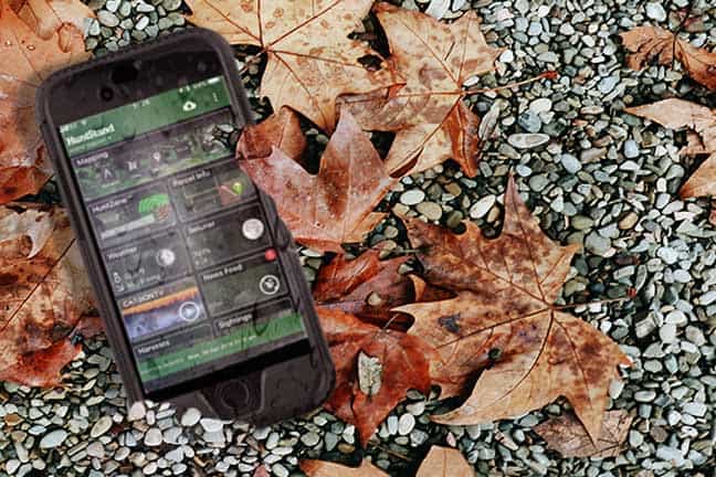
Best hunting gps app for iPhone:
A smartphone has become one of the items that we always check to see that were carrying before leaving the house.
App developers have noticed that mobile cell phones give an ideal platform for hunting apps with the use of GPS.
Although a dedicated handheld GPS offers better coverage and battery life, along with more accuracy. If you know your going to be in an area with decent cell phone coverage, a smartphone offers a great alternative.
Below I have written an overview of 4 of the most popular apps available on the Apple itunes store aimed at the hunter. This overview will help you make a decision on the best hunting GPS app for the iphone currently on offer.
This app helps the hunter map and manage hunt areas. You can add features, sightings, harvests and other useful information to the activities in your hunt area.
Sign up for free with your email and a password, then to go a GPS map and simply use the pointer tool to plot your first hunt area.
Once the area has been selected, you can add stands, food plots, sightings, harvests and other data to the hunt area you have selected.
The hunt zone feature provides data on the wind speed and direction for the next 72 hours from the point you selected when setting up your hunt area.
The hunt zone is depicted by a target on concentric circles, green highlighting where your scent may be picked up and red for the “kill zone”. It’s possible to move the target around the screen just by swiping your finger on the touch screen.
The parcel info feature allows you to quickly check an area for property ownership and boundary data. The data is pulled from a government source and covers 90% of the United States.
You have 10 free requests per month for the data. Again it’s just a simple matter of tapping on the screen where you would like the information presented.
There are lots of other great features as well such as creating club pages to share your harvests and sightings along with a group board. It’s a very smooth operating app, why not go check it out.
Scoutlook Hunting app
Scoutlook is a free app providing basic information to help the hunter. The interactive GPS map allows you to get pinpoint weather forecasts, GPS property lines along with distance and area measurement tools.
There are deer and other game logging tools allowing you to save information for locations of treestands, blinds and trail cameras.
The property lines information is only available for free for the first 7 days, after which it is a subscription service at $5.99 a month at the time of writing this in 2018. There is also an advert free version for $9.99 although the ads are not too intrusive to using the app.
The app also has a scent cone, highlighting wind speed and direction based on the location you have provided.
Overall it’s a fairly basic app but it does the job and has been downloaded over 8,500 times on the app store receiving an overall rating of 4 stars. Check it out here.
HuntWise app
Huntwise has a great set of tools to help the hunter. The toolset allows you to add markers to the GPS map depicting whether it’s a ground blind, a trail camera, base camp and pretty much any key location that you may want to add to the map using the 12 custom pins.
The markers also have the ability to add the ideal wind direction along with other notes for each location.
The maps have great detail, offering different layers of Topographic contours and satellite layers.
The public and private land boundaries data, however this is only available a a 7 day free trial. The cost for full use has 2 options, $4.17 monthly, billed yearly or $9.99 a month.
Overall the Huntwise app is a very slick operating piece of software that provides the hunter with a great toolkit to get the job done!
iSolunar Hunting & fishing Times
The iSolunar app as the name suggests focuses on the best times of day to hunt and fish. It provides information depending on your chosen location for the most productive times of day.
The technology behind this is based around the “Solunar Theory”. Feeding and activity intensify day to day throughout the month according to the moon phase. The best activity occurs around a full moon and a new moon. The data is provided in a simple scale of 1 being fair and 4 being the best time to hunt.
There is the usual GPS mapping, allowing you to add markers for blinds, food plots and trail cameras. Custom maps where you can save the data for future is via an in app purchase.
Weather forecasts for your chosen location are provided along with a 4 day forecast.
iSolunar approaches the hunting app features list with a unique approach. It has many 4 and 5 star reviews on the Apple app store, so why not go check it out.
Summary
All the hunting apps offer very similar features, with the exception of the iSolunar app. They all operate very smoothly on the map screen and provide a wealth of data to help you hunt.
The biggest factor when using a GPS app on a smartphone is battery life. There’s only really 2 options here.
Use a handheld GPS which does provide far better accuracy and battery life.
Carry a powerbank, 10,000mAh will keep you going all day.
I hope you found this article useful. Go take a look at all 4 apps, and see which one is most suited to your hunting requirements, or perhaps download all 4 and test them for yourself.